So you’ve read the warnings and qualifications, here’s the info… (back to the Warnings and Qualifications)
The White Salmon Trail and the Cougar Loop / Razor Hone Trails are old Forest Service logging roads that have a gravel base, ditches, culverts, and can be driven on during the summer. (well, only sort-of for the Cougar Loop). The Connector trail is NOT. It is a winter-only trail that has been cleared to a width of six feet (mostly), on a route that is not too steep, with not too many logs left to climb over or under. It swings by the White Salmon Creek with a couple of very nice overlooks and goes through some massive old-growth cedar. It is well removed from where ‘everyone goes’. As winter-only, it does not have a solid ‘path’ to walk on – it is expected to have snow cover to keep you from falling into holes, etc.
Its length is a little less than 4 miles – and my target speed when working on it was 1 mph. At first, we weren’t anywhere close to that, but now I think it’s manageable. I do not recommend end-to-end travel without getting some experience on the trail – but a time budget of something like 1 hour down White Salmon to the top, 4 hours on the Connector, and 1 hour down Cougar and Razor Hone might be doable (or maybe not, it all depends!) You should be prepared for deep snow and be ready to cross little streams that have melted out deep ‘canyons’ in the snow.
Method of travel: you are welcome to make your own choice. I have been down to point B (White Salmon Cr. Overlook) and up to point D (Big Tree Meetup) using both Hoks and backcountry skis (90 mm at the shovel). Others with me have used snowshoes – but when we did our first through trip, we skied to the starting point and then switched to snowshoes. Eventually, I’m hoping to have the trail ready for an experienced backcountry skier to ski the entire length – but we aren’t there yet.
The trail is marked: There should be a blue diamond in sight from almost any point on the trail, looking in either direction. But remember – they can be covered with snow, branches can hang down in front of them, they can come loose, the tree that they are on can fall down. Broadly speaking, there aren’t a lot of sharp turns on the trail, but there are a couple. We have attempted to put an orange snow pole at every serious turn. If you get to an orange pole, stop and look around for a change in direction of the trail.
Lessons from our first through trip: I still think the trail itself is suitable for backcountry skis, BUT as snow sheds off the trees in some sections of the upper half, it forms a snaky ridge that runs between the tree-wells on either side of the trail. It’s not that you are going to fall into the tree-wells, it’s just that it doesn’t make for smooth skiing. Snowshoes seem more appropriate. There are a number of mini-creek crossings. None was terribly difficult nor dangerous, but you had to plan your steps. And our snowshoes dragged in the water occasionally. There was a blue diamond in sight on almost every point of the trail. If you’ve gone for 100 feet and haven’t found a diamond, stop and look around – it is likely that you have gotten off the trail. We carried our skis with the tips above our packs and did not have significant trouble with them catching in branches.
Map Legend is a work in progress…
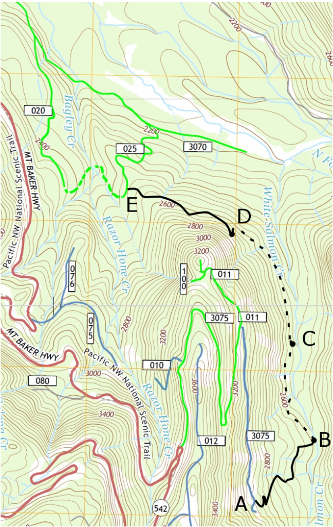
Out and back trips from either the top or bottom would make a good expedition for a day.
From the top:
- From the parking area to point A is the White Salmon Trail and the SE Extension, together about 2.7 miles.
- Point B is the ‘White Salmon Creek Overlook‘, a pretty, rocky outcrop above the creek. It would make a great destination for lunch and a turnaround spot for your first trip (with a long uphill return trip). (The actual overlook is just off the main trail, (maybe 50-100 ft) but you see it as you go by (and start going back uphill). Stop and enjoy the setting!)
- Segment AB is about 0.8 miles
- The midpoint is another 0.9 miles.
From the bottom:
- From the parking lot to point E is about 3.1 miles. I usually go up Far Cougar on the way out, then back to the lot down Near Cougar.
- Point D is ‘Big Tree Meetup‘, a grove of giant trees. A great destination for lunch and a turnaround spot for your first trip.
- Segment DE is about 0.8 miles.
- The midpoint is another 1.2 miles.
There is a sign and a map at each end of the trail. There is a trail register at the midpoint. Send me an email at ski@tryonhayes.com if you want to discuss the section between B and D. Or if you’d like to join me on a trip. Or if you have some comments. Or if you want to send me a trip report. Or if you want to volunteer to work on it next summer. – Pete Tryon
If you’re not sure and want to get more of an idea of the trip, check these pages: