Back to Main Salmon Ridge Sno-Park page
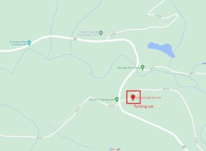
Location: Google Maps will actually show you the way, if you search for ‘Salmon Ridge Sno-Park’. Drive out State Highway 542 towards Mt. Baker, through the town of Glacier. Watch the mileposts. Just past MP 46, you will see the large highway department maintenance buildings on the left. Slow down. You will then go around a fairly sharp right-hand bend in the highway. Stay slow. You will cross the bridge over the North Fork of the Nooksack River. Stay slow, it can be slippery. One hundred feet or so beyond that you will see the Forest Service sign for a campground on the right – opposite from that, turn LEFT into the big parking lot for the sno-park.

To a new skier heading east out of Bellingham, the names one hears may prove confusing. These three are often used as the destination name for a cross-country ski trip up the Mt. Baker Highway.
- Salmon Ridge SnoPark – the designation of the parking lot and the general area by Washington State Parks (link takes you to the Washington State website.)
- Razor Hone – The main trail that leaves the main parking lot and runs for about 5 km along an old Forest Service road. It is the trail that is most likely to be groomed and is suitable for beginners.
- White Salmon – A trail that leaves a small parking area off of a sharp switchback part way up the mountain. It is higher than Razor Hone and has better snow, but is less likely to be groomed. Be very careful entering and leaving the parking area.
You might also hear people talking about smaller trails that are part of this area. Check the map or go exploring for more details on the Cougar Loop, Mom’s, Huckleberry, Hannegan Pass Road, Anderson, Galena Rd and more.